THE HARBOUR
Morphology
Brindisi has a wonderful natural
harbour that, thanks to its conformation and geographic
position (latitude 40°39'00'' north, longitude 17°58'00''
east), has always been known as one of the safest of
Adriatic Sea. It is located in a wide funnel-shaped
bay wedged into the coast.
Brindisi has always been considered as the Gate to the
East, and has been for decades the privileged point
for binding Italy, Greece and East Mediterranean Sea.
The port is
made up essentially of three basins:
(A) - The external port, of 3.000.000 square
mt. area, bound from South by the mainland, from East
by the Pedagne islands (1),
from West by the St.Andrea island
(2) and
the upper side of Costa Morena dock (3)
and from North by the Punta Riso
seawall (4).
(B) - The medium port,
of 1.200.000 square mt. area, formed from the stretch
of water ahead the channel of access to the inner port,
called Pigonati Channel (6),
the Bocche di Puglia basin (5)
and the Costa Morena dock on
south side (7).
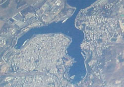
(C) - The inner port,
about 727,000 square mt. area, is formed by two long
arms "embracing" the old side of the city
to North and East, respectively named "Seno di
Ponente" (West Cove - C1)
and "Seno di Levante" (East Cove -
C2).
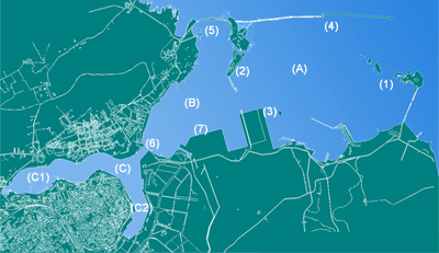
Map of Brindisi Harbour - by
Brindisi Port Informer
During years, the
city developed and extended only towards inland, due
to already existent military and industrial installations
that constrained the civilian expansion.
 The
unique branched conformation of natural harbour of Brindisi
is the effect of the erosion corresponding to the mouth
of water streams: Cillarese channel that nowadays ends
into West Cove, and Palmarini-Patri channel that ends
into East Cove; they formed a river valley that subequently
was flooded by the sea. The
unique branched conformation of natural harbour of Brindisi
is the effect of the erosion corresponding to the mouth
of water streams: Cillarese channel that nowadays ends
into West Cove, and Palmarini-Patri channel that ends
into East Cove; they formed a river valley that subequently
was flooded by the sea.
In the past there was a third "branch" of
the inner port, called Mena Channel, that was closed
and filled up during XVIII century, nowadays corresponding
to Corso Garibaldi.
In the past, other
two channels ended in the medium port; in the Middle
Age they were named Delta and Luciana, and afterwards
known as Fiume Grande and Fiume Piccolo. They are still
visible in the nearby of industrial area, and are interesting
naturalistc resources.
Docks
and utilities
In East Cove of inner port there are ten active docks,
including Santa Apollinare, Punto Franco, Feltrinelli,
Carbonifera, Dogana and Centrale.
In the medium port, mainly dedicated to commercial traffic,
there are the docks named Costa Morena and Punta delle
Terrare.
In the external port there are the industrial docks.
«
Back
|